 ©1999FOGS ©1999FOGS
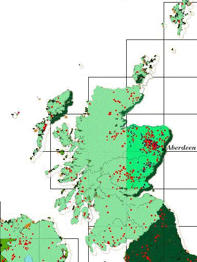
Aberdeenshire, Banffshire, Moray and Kincardineshire are
counties in NorthEast Scotland with the highest density of prehistoric and early-historic
monuments per square mile in the whole of the United Kingdom of Great Britain &
Northern Ireland. Recumbent Stone Circles in Neolithic heartland are shown in red; Pictish
symbol stones and other carved stones [Classes I and II, from ADc.600-840] are
shown in purple.
 ART OF THE PICTISH SYMBOL STONES ART OF THE PICTISH SYMBOL STONES
There is a marked preference for Class I stones [incised simple geometric and sacred
animal shapes of earlier provenance] in Aberdeenshire and Banffshire, presumed to be
pre-Christian. Later Class II [cross-carved relief slabs, decorated symbols] are found
clustering in Forfar, Montrose, Forteviot and Fife, and in isolated pockets in Moray, e.g.
Kineddar, Dyke & Elgin and in Aberdeenshire's Maiden Stone. One other stone in Aberdeenshire, the Monymusk cross slab, is unique and may show the first transition between
simpled incised carving and the later Christian art of decorated relief work.
- If Class I stones range in time until AD7-8th centuries, with
Class II following the Christianization of Pictland under King Nechtan
(706-724, d.734), then Cross slabs without symbols are presumed to date from late 9th
century after Scots takeover of Pictland and are known as 'Class III', as with Sueno' Stone. They are usually heavily decorated with 'Celtic'
ornament in relief and feature horsemen, battle scenes, the royal hunt and have lost any
connection with Pictish symbolism.
- Simple incised crosses on rocks, slabs and undressed stone
[sometimes known as Class IV] are usually found without any other ornament and may date
from the late 7th-early 8th Century.
They may be contemporary with the first ogham inscriptions carved into Pictish symbol and
cross-incribed stones.
All can be found in the Grampians stretching from inland Banffshire to the east coast.
While Neolithic and Bronze Age monuments such as the famous Recumbent Stone Circles are
found on higher ground predominantly in the heartland of the Garioch [pronounced Gee-ree]
and along the valley of the River Don, these radiate outwards in ripples covering the
Northeast. Through Bronze Age, Iron Age and into early-Historic times, well after the
Roman retreat, these monuments continued as sacred sites for the gathered populace. While
the Picts (ADc.297-843) appear to have venerated the same ancestral places, their
symbol stones were erected on better agricultural land, usually within a mile of running
water.
 Pictish placenames survive
in profusion in this rich agricultural land and, if allowed to perpetuate without
corruption or misrepresentation, can provide a unique resource in understanding the
history of Northern Pictland. Our sister society, the Scottish
Place-name Society, exists to foster research and perpetuation of the study and value
of placenames. Pictish placenames survive
in profusion in this rich agricultural land and, if allowed to perpetuate without
corruption or misrepresentation, can provide a unique resource in understanding the
history of Northern Pictland. Our sister society, the Scottish
Place-name Society, exists to foster research and perpetuation of the study and value
of placenames.
|

