With the exception of the
Dee and the North Esk, which belong only in part to Kincardineshire, the
rivers of the county arc comparatively small. But from its diversified
and unequal surface, and from the fact that the land slopes in many
directions, the streams •are numerous, and every part of the county is
well-watered. By reclamation, drainage, and improved cultivation, and
the consequent disappearance of water-logged haughs adjacent to rivers,
the streams arc smaller than formerly, but admirably adapted for the
natural and the artificial drainage of their districts. The course of
the streams flowing from the Grampians to the North Sea shows the
general slope of the county to be towards the south-east. The northern
district is drained by numerous tributaries discharging into the Dee,
and the western by the North Esk and its feeders.
The Dee, 96 miles from source to sea, issues out of Bracriach, one of
the Cairngorm summits, at the “Wells of Dee,” and flowing eastward,
enters Kincardineshire near Potarch. Through the three-spanncd bridge of
Potarch, between Aboync and Banchory, it sweeps deep and strong over its
gravelly bed. The road over Cairn o’ Mount, the much-frequented old road
from Tay to Dee, formerly crossed here by a ford below the bridge. For
12 miles the river continues its course through the county, and then
forms the northern boundary for the remaining 14 miles. From Kincardine-O’Neil
it receives the Canny (9 miles) directly below Inchmarlo House and close
to Invercanny reservoirs, connected with the Aberdeen water supply ; and
also the small burns of Cluny and Corrichie from the Hill of Fare. On
the south side the Feugh (20 miles), from the Forest of Birse, flows for
8 miles to Whitestone. There it is joined by the Aan (10 miles), which
comes along the county boundary from Mount Battock, and at Ivirkton of
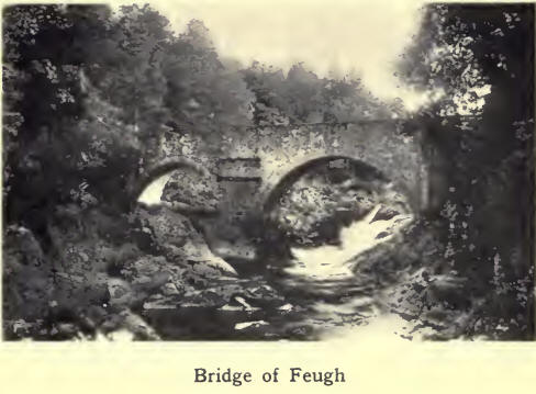
Strachan by the Dye from Glen Dye. The Bridge of Feugh, 350 yards from
the point where the Feugh and Dee join, is one of the most noted and
beautiful spots on Deeside. The bridge itself, a plain structure,
derives its picturesqueness from the rocky channel of the river both
above and below it. Here the stream, embowered in a wealth of wood and
greenery, courses swiftly over and around ledges of projecting rock, the
foaming water, especially when the river is in flood, forming a
magnificent spectacle. Though neither the longest nor the largest river
in Scotland, the Dee lays claim to being one of the most rapid. Rising
4000 ft. above sea level and fed by numerous mountain streams, it has a
flow of water remarkably pure, although it is subject to high and sudden
floods. Its banks, throughout its entire course, are extremely
well-wooded, while as a salmon stream it has few equals.

The North Esk, sometimes
called the East Water, has a course of 40 miles to the sea from its
source in Loch Lee in Forfarshire. Towards the foot of Glen Esk it
touches Kincardineshire, and for the next 14 miles forms the south-west
boundary of the county. For romantic beauty its course of 5 miles
through the beautiful woods of the Burn could hardly be surpassed. Here
the river has ploughed out for itself a deep gorge between rugged rocks,
along which are pleasant winding paths, shaded by overhanging foliage.
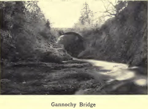
From the “ Loup’s Brig,” as well as from Gannochy Bridge, a lofty arch,
30 feet high and 52 feet wide, on the Fettercairn to Edzell road, the
foaming cataracts and dark pools confined between the rocks and cliffs
form a scene of surpassing beauty and grandeur. The Esk drains an area
of 224 square miles, 80 of which belong to Kincardineshire. The river
has shifted its mouth several times in recent centuries, as is shown by
an examination of the triangular patch of alluvial soil and sand, north
of its present mouth. Up to the end of the eighteenth century it entered
the sea 2 miles, and up to 1879 1 mile, further north than it enters
now. The Luther (12 miles) is the largest feeder of the North Esk from
within the county. Encircling Strathfinella Hill, it flow’s first
through the beautiful glen of Drumtochty, then sweeping southward and
westward through the Howre, it joins the North Esk about 2 miles from
the village of Mary kirk.

Of the other streams in
the east, the Bervie (16 fiyles) is the largest and most interesting.
From the uplands of Glenbervie, it takes a south-easterly course, rounds
Knock Hill, and winds through the fertile haughs of Fordoun and
Arbuthnott, reaching the sea at Bervie. Its banks are picturesquely
wooded near the old mansion-house of Arbuthnott. The Bervie is a famous
trouting-stream, and has a salmon-fishery at its mouth. The bum of
Catterline in the east of Kinneff; the burn of Benholm in Benholm
parish; and the burn of Finella in St Cyrus, enter the sea through
gorges worn by the water in the rocks that crown their banks. The Den of
Finella with its waterfall 70 ft. high rivals in grandeur the scenery of
the North Esk at the Burn, though not on so extensive a scale. Tradition
relates that, when Queen Finella was pursued after the murder of King
Kenneth III., she fled here,
“And leapt from the rocks
to a wild, wild boiling pool,
Where her body was torn and tossed.”
The lochs in the county
are few and small. The Loch of Leys in Banchory was over 2 miles in
circuit, but is now drained; Loirston Loch in Nigg is 27 acres in
extent. There are two extremely pretty artificial lakes in the county.
That within the policies of Fasque House is 20 acres in extent; and
Glensaugh Loch, in the upper part of Drumtochty Glen, has certainly now
little appearance of being artificial. Both have wooded islets, and are
the haunts of wild duck and other water fowl.
|

