|
BY a gradation of
ancient sea beaches which can be traced along the Clyde valley in
the vicinity of Glasgow, the occurrence of successive upheavals of
the land is fully established, and it is obvious that during some
part of the remote period immediately preceding the last of these
elevations the estuary of the Clyde at Glasgow was several miles
wide, covering not only the lower districts of the city but
extending to the base of the Cathcart and Cathkin Hills, and
probably receiving the waters of the river not far from Bothwell.
That this district was then inhabited by man seems to be placed
beyond reasonable doubt by the discovery of canoes in the Trongate
and other localities far above the present level of the river, but
all of them covered by strata of transported sand and gravel.
One canoe was
unearthed in 1780, when excavations were being made for the
foundation of St. Enoch's Church; another was found at the Cross,
when similar preparations were in progress for the erection of the
Tontine buildings; one was got in Stockwell Street, near the present
railway crossing ; and another was dug up on the slope of the
Drygate. All these canoes were formed of single oak trees roughly
scooped out, fire having been employed to burn out the interior, and
were altogether of the most primitive kind of construction, 1 a
description which likewise applies to a number of other canoes that
were found on the lands of Springfield and Clydehaugh on the south
side of the Clyde. These latter canoes, discovered during operations
for the widening of the harbour between 1847 and 1849, seem to have
been deposited at a much later period than those found in higher
ground. No change in the relative positions of land and sea had
apparently taken place between the time when they were swamped or
settled down in the channel of the river till they were again
exposed to the light of day. The St. Enoch's Square canoe was 24
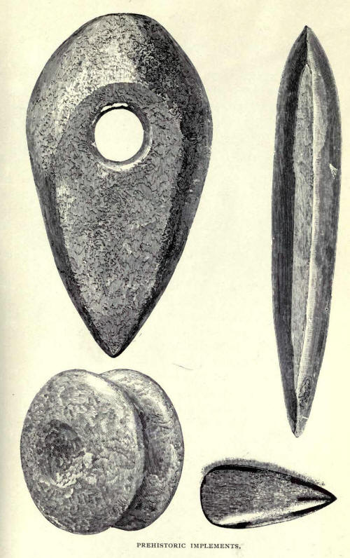
feet below the surface, and there was found within it a polished
stone hatchet or celt, one of the instruments which may have been
used in its construction, though it seems as much adapted for war as
for any peaceful art.2
During long ages
which succeeded the final settlement of sea and land level, the
Clyde, running through a tract of
1 A fifth canoe,
discovered in 1825 when opening a sewer in London Street, was built
of several pieces of oak, and exhibited unusual evidences of labour
and ingenuity (Daniel Wilson's Prehistoric Annals, p. 35)
2 Ibid. A sketch of
the celt, given by Mr. Wilson, is here reproduced. All the canoes
discovered in the higher grounds on the north side of the river were
destroyed, and no sketch of their appearance or record of their
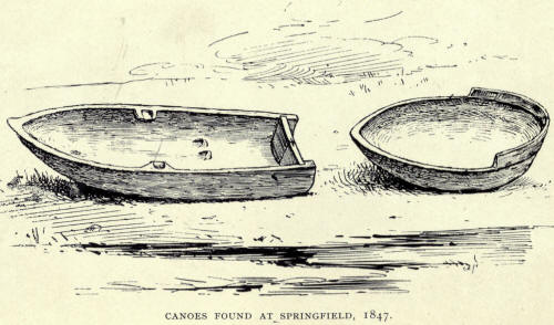
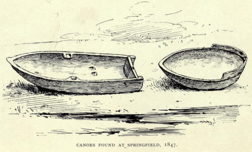
dimensions has been preserved. Representations of two of the canoes
found at Clydehaugh, as shown in Scottish History and Life, are here
reproduced : No. 1 measured 14 feet in length, 4 feet 1 inch in
breadth, and 1 foot 11 inches deep; No. 2 was so feet long, 3 feet 2
inches broad, and 1 foot deep.
For fuller
information and interesting speculation on the prehistoric subjects
alluded to in the text reference may be made to Ancient Sea Margins,
by Dr. R. Chambers, pp. 203-9; Daniel Wilson's Prehistoric Annals,
pp. 3I-37; Macgeorge's Old Glasgow (i88o), pp. 248-62; John
Buchanan's narrative in Glasgow : Past and Present (1856), iii. pp.
555-79; Transactions of Glasgow Archceological Society, 1st Series,
I. pp. 188-90; II. pp. 525-30. In the last of these Archaeological
Society's papers Mr. J. Dalrymple Duncan gives an account of the
discovery at Point Isle in 1880 of a canoe which crumbled to pieces
in the hands of those who attempted its removal.

country with no
proper river channel, must have been continually changing its
course, and in the tidal area, specially, not only the bed of each
changing channel, but likewise the land on either side would by
silting process be gradually raised. But the bulk of the sediment
would collect wherever the water had its course for the time, and so
soon as the accumulation became higher than the adjoining ground,
the former channel would be deserted and a new one chosen. Many of
these river variations can still be identified, and it is believed
that such a change is sufficient to account for the Springfield
canoes being found seven feet below the natural bed level of the
river and one hundred yards to the southward of its bank, as these
existed before the artificial deepening which was commenced in 1758
and the widening carried through by the Clyde Trustees in 1847. Such
flooding effects and silting process are also regarded as sufficient
to account for the covering by stratified sand of the beautiful
Roman bowl of Samian ware which, in 1876, was discovered in the
Green, about 4½ feet below the surface.
It was not till
comparatively modern times that the river, in its passage through
that part of the valley which is now city territory, permanently
settled into its present course, and even after embankment,
deepening and other artificial operations and appliances were
adopted, the lower lying grounds, such as Glasgow Green and the
Broomielaw area, were subject to ever recurring floods, which kept
them to a large extent in a more or less swampy condition. The havoc
caused to grain crops by such floods would not often be turned to so
providential a purpose as on the occasion when the scornful king's
barns with their stores of wheat were carried away by the river and
deposited on the banks of the Molendinar to feed the brethren of St.
Kentigern's monastery. [St. Kentigern (Scottish Historians), pp. 69,
70.] Nor would many floods be so disastrous as that of 1454,
altogether of the most primitive kind of construction, [A fifth
canoe, discovered in 1825 when opening a sewer in London Street, was
built of several pieces of oak, and exhibited unusual evidences of
labour and ingenuity (Daniel Wilson's Prehistoric Annals, p. 35)] a
description which likewise applies to a number of other canoes that
were found on the lands of Springfield and Clydehaugh on the south
side of the Clyde. These latter canoes, discovered during operations
for the widening of the harbour between 1847 and 1849, seem to have
been deposited at a much later period than those found in higher
ground. No change in the relative positions of land and sea had
apparently taken place between the time when they were swamped or
settled down in the channel of the river till they were again
exposed to the light of day. The St. Enoch's Square canoe was 24
feet below the surface, and there was found within it a polished
stone hatchet or celt, one of the instruments which may have been
used in its construction, though it seems as much adapted for war as
for any peaceful art.
[Ibid. A sketch of
the celt, given by Mr. Wilson, is here reproduced. All the canoes
discovered in the higher grounds on the north side of the river were
destroyed, and no sketch of their appearance or record of their
dimensions has been preserved. Representations of two of the canoes
found at Clydehaugh, as shown in Scottish History and Life, are here
reproduced: No. 1 measured 14 feet in length, 4 feet 1 inch in
breadth, and 1 foot 11 inches deep; No. 2 was 10 feet long, 3 feet 2
inches broad, and 1 foot deep.
For fuller information and interesting
speculation on the prehistoric subjects alluded to in the text
reference may be made to Ancient Sea Margins, by Dr. R. Chambers,
pp. 203-9; Daniel Wilson's Prehistoric Annals, pp. 3I-37;
Macgeorge's Old Glasgow (i88o), pp. 248-62; John Buchanan's
narrative in Glasgow: Past and Present (1856), iii. pp. 555-79;
Transactions of Glasgow Archceological Society, 1st Series, I. pp.
288-90 II. pp. 121-30. In the last of these Archaeological Society's
papers Mr. J. Dalrymple Duncan gives an account of the discovery at
Point Isle in i 880 of a canoe which crumbled to pieces in the hands
of those who attempted its removal. ]
During long ages which succeeded the
final settlement of sea and land level, the Clyde, running through a
tract of

country with no proper river channel,
must have been continually changing its course, and in the tidal
area, specially, not only the bed of each changing channel, but
likewise the land on either side would by silting process be
gradually raised. But the bulk of the sediment would collect
wherever the water had its course for the time, and so soon as the
accumulation became higher than the adjoining ground, the former
channel would be deserted and a new one chosen. Many of these river
variations can still be identified, and it is believed that such a
change is sufficient to account for the Springfield canoes being
found seven feet below the natural bed level of the river and one
hundred yards to the southward of its bank, as these existed before
the artificial deepening which was commenced in 1758 and the
widening carried through by the Clyde Trustees in 1847. Such
flooding effects and silting process are also regarded as sufficient
to account for the covering by stratified sand of the beautiful
Roman bowl of Samian ware which, in 1876, was discovered in the
Green, about 41 feet below the surface.
It was not till comparatively modern
times that the river, in its passage through that part of the valley
which is now city territory, permanently settled into its present
course, and even after embankment, deepening and other artificial
operations and appliances were adopted, the lower lying grounds,
such as Glasgow Green and the Broomielaw area, were subject to ever
recurring floods, which kept them to a large extent in a more or
less swampy condition. The havoc caused to grain crops by such
floods would not often be turned to so providential a purpose as on
the occasion when the scornful king's barns with their stores of
wheat were carried away by the river and deposited on the banks of
the Afolendinar to feed the brethren of St. Kentigern's monastery.
[St. Kentigern (Scottish Historians), pp. 69, 70.] Nor would many
floods be so disastrous as that of 1454, described by one of our
chroniclers as "ane richt greit spait in Clyde, the xxv and xxvj
days of November, the quhilk brocht doun haile houssis, berms and
millis, and put all the town of Govane in ane flote quhill thai sat
on the houssis." [Ane Schort Memoriale of the Scottis Corniklis (Auchinlek
MS.), p.18.]
But apart from such extreme occurrences the floods experienced so
recently as the eighteenth and nineteenth centuries, as described by
personal observers, were so serious that one may conceive how little
inducement there was for the early inhabitants to plant their
habitations near the river before a way was discovered for keeping
it within reasonable bounds. If, therefore, the banks of the
Molendinar were inhabited by man in these prehistoric times, his
dwellings must have occupied the higher grounds, and it is
significant that in the earliest account we have of the
comparatively modern days of St. Kentigern it is that part of the
city which is referred to. Joceline, the biographer of St. Kentigern,
writing in the twelfth century makes mention of a cemetery which had
been "long before" consecrated by St. Ninian, and this ancient
cemetery was evidently identified as having occupied the site of the
Cathedral and its adjoining burying ground.
Cathures, which Joceline gives as the
former name of Glasgu, is understood to bear the interpretation of a
fort or encampment, and may well have been applied to the site of
those dwellings placed on the higher grounds, between the Molendinar
and Glasgow Burns, and occupied by a primitive community which had
probably grown up and prospered under the protection of some
powerful chief. In later times this district, traversed by an old
Roman road and including the inhabited area bearing the archaic
designation of Ratounraw, was possessed by rentallers who were
subject to a special bailliary jurisdiction of unknown origin. Early
churches were often planted in such places, and there, as a general
rule, is

to be found the nucleus of the village,
the town and the city.
With the coming of St. Kentigern the
real beginning of Glasgow as a city has aways been associated, and
notwithstanding irregularities in progress and the untoward
vicissitudes of the intervening centuries, it may safely be assumed
that by the time we have the benefit of the few fragments of twelfth
century writings which are still extant, inhabited dwellings had
begun to spread over the lower grounds near the margin of the river.
Keeping within the bounds of the two streamlets, the Molendinar on
the east and Glasgow Burn on the west, the banks of the former seem
to have attracted the bulk of the earlier settlers, but rentallers
of croft land lying along the foot of Glasgow Burn are also traced,
and here, according to ancient tradition, were laid the earthly
remains of St. Kentigern's mother on the spot where the chapel
bearing her name was reared. The ruins of St. Tenew's Chapel were
still in evidence till well on in the eighteenth century, and though
the circumstances connected with its foundation must remain in
obscurity, seeing that any accounts we have of St. Mungo's birth and
parentage are mainly legendary fable and that we have little or no
reliable information on his domestic affairs, there seems to be no
inherent improbability in the substantial correctness of the
traditional story. Another chapel, likewise of unknown antiquity,
was planted in the more populous district just referred to, and was
dedicated to the Virgin Mary.
|

