|
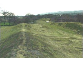
Remains of the Antonine Wall
 It may not be out of place to give
here some account of the wall of Antonine. The wall or rampart
extended from Carriden on the Forth, two miles west from
Blackness, and about the same distance east from Bo'ness, to West
Kilpatrick on the Clyde. The date, which may be depended on,
assigned to the building of the wall is between 138 and 140 A.D.
Taking the length of this wall from Kilpatrick on the Clyde to
Caeridden or Carriden on the Forth, its extent would be 39,726
Roman paces, which exactly agrees with the modern measurement of
36 English miles and 620 yards. This rampart, which was of earth,
and rested on a stone foundation, was upwards of twenty feet high
and four and twenty feet thick. Along the whole extent of the wall
there was a vast ditch or prútentura on the outward or north
side, which was generally twenty feet deep and forty feet wide,
and which, there is reason to believe, might be filled with water
when occasion required. It may not be out of place to give
here some account of the wall of Antonine. The wall or rampart
extended from Carriden on the Forth, two miles west from
Blackness, and about the same distance east from Bo'ness, to West
Kilpatrick on the Clyde. The date, which may be depended on,
assigned to the building of the wall is between 138 and 140 A.D.
Taking the length of this wall from Kilpatrick on the Clyde to
Caeridden or Carriden on the Forth, its extent would be 39,726
Roman paces, which exactly agrees with the modern measurement of
36 English miles and 620 yards. This rampart, which was of earth,
and rested on a stone foundation, was upwards of twenty feet high
and four and twenty feet thick. Along the whole extent of the wall
there was a vast ditch or prútentura on the outward or north
side, which was generally twenty feet deep and forty feet wide,
and which, there is reason to believe, might be filled with water
when occasion required.
This ditch and rampart were
strengthened at both ends, and throughout its whole extent, by
about twenty forts, three being at each extremity, and the
remainder placed between at the distance of about two English
miles from one another; and it is highly probable that these
stations were designedly placed on the previous fortifications of
Agricola. The following, going from east to west, are the names
and sites of some of the stations which have been identified:-
Rough Castle, Castlecary, Westerwood, Bunhill, Auchindinny,
Kirkintilloch, Bemulie, East Kilpatrick, Castlehill, Duntocher,
West Kilpatrick. It will be seen that to a certain extent they are
on the line of Edinburgh and Glasgow railway, and throughout
nearly its whole length that of the Forth and Clyde canal. Its
necessary appendage, a military road, ran behind the rampart from
end to end, for the use of the troops and for keeping up the usual
communications between the station or forts.
From inscriptions on some of the
foundation stones, which have been dug up, it appears that the
Sixth legion, with detachments from the sixth and twentieth
legions and some auxili aries, executed these vast military works,
equally creditable to their skill and perseverance. Dunglas near
the western extremity, and Blackness near the eastern extremity of
the rampart, afforded the Romans commodious harbours for their
shipping, as also did Crammond, about five miles west from
Edinburgh. This wall is called in the popular language of the
country Grime's or Graham's Dyke. In 1868 a large oblong slab, in
first-rate preservation, was dug up at Bo'ness, in the parish of
Kinneil (Bede's Peanfahel, "the head of the wall"),
containing an inscription as distinct as it was on the day when it
came from a Roman chisel. The remarkable stone is now in the
Scottish Antiquarian Museum.
We have no distinct mention of
the Caledonians again until the reign of Commodus, when, about the
year 183, these troublesome barbarians appear to have broken
through the northern wall, slain the general in command of the
Roman forces, and pillaged the lowland country beyond. They were,
however, driven back by Ulpius Marcellus, who succeeded by prudent
management in maintaining peace for a number of years. In the
beginning of the reign of Severus, however, the Caledonians again
broke out, but were kept in check by Virius Lupus, who appears to
have bribed rather than beaten the barbarians into conformity.
The
Antiquarian rediscovery of the Antonine Wall
By Lawrence Keppie (pdf) |

