|
ALEXANDER BLACK was born on 25 May 1827 at
Arndilly, Banffshire, Scotland, son of James Black and Isabella Middleton,
née Riach. After receiving a good education as a land surveyor in Aberdeen
and then completing his articles, he acted for some time as assistant
factor on several estates, gaining much experience in the improvement and
management of landed property. In Scotland, a Factor (or property manager)
is a person or firm charged with superintending or managing properties and
estates -sometimes where the owner or landlord is unable to or
uninterested in attending to such details personally, or in tenements in
which several owners of individual flats contribute to the factoring of
communal areas.
In 1851,
Alexander Black prepared a report to the Falkirk stentmasters relating to
water supplies from the coal waste areas in Falkirk Muir and the effect of
the Grand Canal. The stentmasters were elected by the merchants and
tradesmen of the town to be responsible for the maintenance of the water
supply and buildings within the town.
Sailing on
the Oriental, he left London in early 1852 and arrived in Port
Phillip on 10 December 1852 at the height of the Victorian gold rushes. He
went to the Castlemaine goldfields, but returned to Melbourne late in 1853
and practised as a surveyor.
On 18 April
1854 he was appointed to the staff of the Victorian government survey
office on trial. On 1 August 1854 he became temporary assistant surveyor
with a salary of £300 and allowances. His first duty was to survey the
township of Lancefield. Later he worked in the Heathcote area and in
central and northern Victoria.
In 1860
when the geodetic survey commenced under Robert Lewis John Ellery, Black
was appointed as one of the surveyors. His work, chiefly in northern and
eastern Victoria, ended with the survey of the boundary between Victoria
and New South Wales, and received high praise from Ellery. Black was well
respected for his surveying, and despite being 'sober, cautious in
outlook, he never failed to win commendation for his thorough methods,
energy and competence'.
In late 1869 Surveyor Alexander Black
determined the position of a spring 22.5 chains (452.6 metres) north-west
of Forest Hill, which he thought to be the correct source of the Murray
River closest to Cape Howe. This was the spring found by the Victorian
surveyor, Thomas Scott Townsend in 1856, that in the period 1862-63, the
New South Wales District Surveyor, Edward Twynam had remarked as the
source of the Murray River nearest to Cape Howe.
With the trigonometric points established,
triangulation of Forest Hill commenced in December 1869 with the objective
being to compute the bearing from the spring near Forest Hill to the mark
at Conference Point. In early 1870 Alexander Black and Alexander Allan
independently commenced running, clearing and marking the boundary line,
finishing in August 1871 – a distance of approximately 180 kilometres.
Black cleared and marked trees, lay rock lines and constructed nine major
rock cairns on the highest points of the boundary line between Forest Hill
and "Allan's peg" (The first cairn at Forest Hill is now known as Townsend
Corner). For the eleven months that Black and his team laboured, the
total cost of this exercise was approximately £2000: £350 salary per year
was paid to Black, £100 for equipment per six months, £45 for the cost of
conveyance, £265 for the packhorses and £5 for their forage.
This section of the border survey held further
challenges, including snow from Forest Hill, multiple crossings of the
icy-cold Snowy River and climbing over Mount Tingaringy (or Tingy Ringy),
with no flowing water between the latter two locations. Their route was
often difficult to navigate as the dense Murray Pine forest allowed a
visibility of less than ten metres. Black's cairns in themselves were
great achievements, but became smaller as he ventured along the border
line.
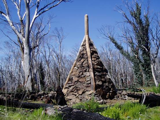
The cairn at Forest Hill (now known
as 'Townsend Corner')
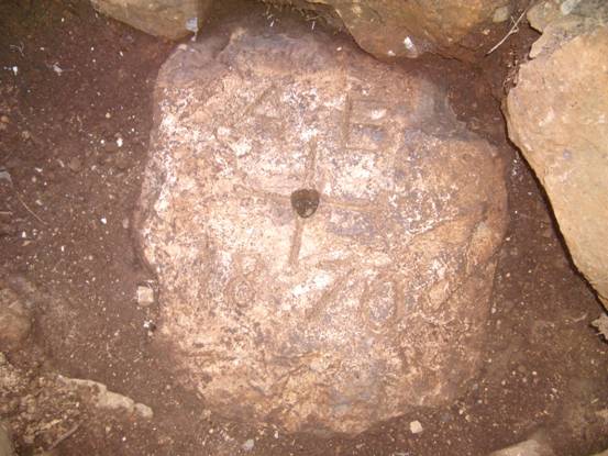
The original ground mark under the
cairn at Forest Hill
It should be noted that the Victorian
surveyors, Alexander Allan and his associate Auguste Tuxen, laid down the
line eastward from the peg (known as "Allan's peg", since found on the
western side of the Delegate River) to Conference Point in twelve months
(August 1869-August 1870) – a distance of 115 kilometres. This was a
survey made through exceedingly difficult country. Their surveyed boundary
line passed within 18.4 feet (5.6 metres) south of the "Conference
Point" mark placed by Ellery and Adams in 1869. Alexander Black and
his helpers traversed the western section of this "straight line" boundary
from the spring at Forest Hill to "Allan's peg".
The survey undertaken by Surveyor Black is
catalogued Trig. 11 Sheet 1 (NSW) and Map BL1A (Department of Lands and
Survey, Melbourne Victoria). The survey undertaken by Surveyor Allan is
catalogued Trig. 11 sheets 2-5 (NSW) and Maps BL2A, 3A-8A (Victoria).
In 1871,
Black was appointed acting district surveyor at Bairnsdale (this was
confirmed on 1 November 1872), where he was also lands officer and
collector of imposts. On 21 January 1873 he was transferred to Sale and on
16 September became district surveyor at Sandhurst where in January 1875
he was also collector of imposts. Although his services were nominally
dispensed with on Black Wednesday, 8 January 1878, at the request of James
Macpherson Grant he continued his daily work until officially restored to
his post. Promoted District Surveyor third class on 5 April and second
class on 1 January 1879, he was appointed assistant Surveyor-General. He
succeeded Alexander John Skene as Surveyor-General on 1 July 1886, holding
that post until his retirement in May 1892. Among other appointments he
had been elected in 1877 a member of the Victorian Institute of Surveyors,
became its president in 1879-80 and served on its council at various
times; in 1880 he was appointed to the Water Conservancy Board and later
with George Gordon, engineer, reported on water problems and irrigation.
He served on two royal commissions, the first on water supply in 1884; at
the second, on the working of the Transfer of Land Act, he also
gave evidence on the accuracy of surveys. In 1870 and 1882 he was deputy
electoral officer; on 1 January 1890 he became deputy-chairman and, after
four months, chairman of the Tender Board on which he served until 1892.
In 1886-93 he was a member of the Board of Land and Works and commissioner
of land tax. Sober and cautious in outlook, he never failed to win
commendation for his thorough methods, energy and competence.
On 14
August 1886 Black married Agnese Constance (b.1859), daughter of Michael
Guilfoyle of Sydney and his wife Charlotte Delafosse, née Austin. Although
Black was an Anglican the ceremony took place at the home of the bride's
brother, director of the Melbourne Botanical Gardens; they had no
children.
Alexander
Black died at his home, Hammerdale, Alma Road, St Kilda, on 13
March 1897 and was buried at the St Kilda cemetery.
……………………………………………………………..
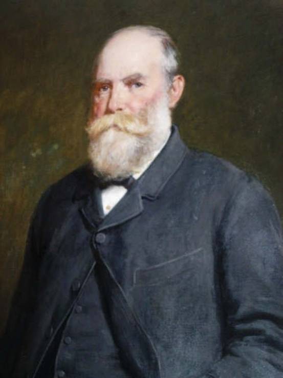
Alexander Black
(1827-1897) |

