 The Great Philadelphia Wagon Road is the story of the Scots-Irish
settlement in America. North America remained a green wilderness for nearly 150
years. There were only trails cut thorough the forest which spread from
New Hampshire to Georgia. The Appalachian Mountains was a stern barrier between
the Atlantic and the unknown interior of the continent. The settlers moved
inland, and followed paths of the which the Indians had hunted and traded, many of
these trails were worn down by the buffalo which once roamed the uplands in search
for food. These paths followed valleys and river shores, extended southward
to the Carolinas. This movement of families, individuals and communities from one
place to another has been the shaping of history. The Great Philadelphia Wagon Road is the story of the Scots-Irish
settlement in America. North America remained a green wilderness for nearly 150
years. There were only trails cut thorough the forest which spread from
New Hampshire to Georgia. The Appalachian Mountains was a stern barrier between
the Atlantic and the unknown interior of the continent. The settlers moved
inland, and followed paths of the which the Indians had hunted and traded, many of
these trails were worn down by the buffalo which once roamed the uplands in search
for food. These paths followed valleys and river shores, extended southward
to the Carolinas. This movement of families, individuals and communities from one
place to another has been the shaping of history.
In the eighteenth
century migrations few trails in America
weren’t more important than the Indian route, which extended to east of the Appalachians from
Pennsylvania to Georgia. This Ancient Warriors Path had long been used by the
Iroquois tribesmen of the north to come to the south and trade or to make war in Virginia
and the Carolinas. By a series of treaties with the powerful Five Nations of the
Iroquois, the English acquired the use of the Warriors Path. After 1744 they took over
the land itself. The growth of the route into the principal highway of the
colonial back country is important in the development of the nation. Over this vast
wagon road came the English, the Scots-Irish and the German settlers to claim land.
The Great Warriors Path led from the Iroquois Confederacy around
the Great Lakes through what later became Lancaster and to Bethlehem,
Pennsylvania to York, to Gettysburg, into the western Maryland around what is now known as
Hagerstown, across the Potomac River at Evan Watkins Ferry following the narrow path
across the "back country" or "up country" or "Piedmont"
to Winchester through the Shenandoah Valley of Virginia to Harrisburg, Staunton, Lexington, Roanoke to Salem,
North Carolina, to Salisbury, where it was joined by the east–west Catawba and
Cherokee Indian Trading Path to at the Trading Ford across the Yadkin River, in Rowan,
North Carolina, thence to Charlotte, to Rock Hill, South Carolina where it branches to
take two routes to Augusta, and Savannah, Georgia.
The Scots – Irish who poured into America from Ulster were
middle class farmers and craftsmen who came from poor rural counties of Northern Ireland
where English rule had grown increasingly severe and where the 1740 famine in Ulster
hastened their departure. They were nearly all Presbyterians. Arriving in Philadelphia,
they made their way westward to Lancaster and Harrisburg, thence south over the
Warriors Path towards the cheaper lands of Virginia, crossing the Potomac by Watkins Ferry.
Wherever they settled they started schools, churches and preached. The Scots - Irish that came to the Colonies were the best
educated of the immigrated groups. At the time of the Revolution there were 600,000
Scots-Irish in America and their literary level was the highest it had ever been. As pioneers, the
Scots - Irish proved their mettle and arrived when the Colonists needed them. There was
little mingling of the people of different nationalities even with people in the
communities. The Scots who was transplanted in the Colonies did not intermarry with the
English or the Irish catholic. When they came to the Colonies and established their
early churches, the Scots did not intermarry with the English or the Palatine neighbors for
two generations. The goal of the Scots was to obtain lands, but for the Scot-Irish
not necessarily to own it. A common grievance against these Scots colonial authorities
was their habit to squatting on the land and not taking claim to it officially. This
action supplies one reason why the expected deed records that would prove the
migration.
Many Scots farmers lacked the skills or the money to adhere to the traditional
Ulster way which combined cropping with herding, and hunting and did not require large
amounts of the best land and invited the movement as the land and the game wore out. The
settlers from Ulster were restless and moved down the Great Philadelphia Wagon Road.
Later Development of the Wagon Road
As it had been done in Pennsylvania, the Great Wagon Road in the
Carolinas and Virginia forced the Indians to move futher westward. Riding along
the Great Wagon Road in the decade before the Ameriacn Revolution, visitors from
Europe expressed amazement at the rapid growth of the interior. Stretched from
Philadelphia to Georgia were endless farms, punctuated by an occasional fort, tavern, or
village. By 1765 the Wagon Road was cleared for horse drawn vehicles. To
maintain the road, County Courts appointed overseers and viewers, who were
responsible for the keeping up with the segments of through fair at the County expense.
Packhorse trains vied with wagons as carriers of the frontiers
goods, a rider on the lead horse led as many ten to twelve horses in procession, the belled
bridle of each being attached to the saddle, of the preceding horse, each horse being
equipped to carry up to six hundred pounds. Besides wagoners and packhorses drivers, the Great Wagon
Road was swamped in the summer with drivers that smelled like a
barnyard, leading and driving livestock to market, aided by shepherd dogs.
Entire families road horseback along the road to settle a new
farm or found a new church. The Great Philadelphia Wagon Road grew larger and longer, and so
did the Conestoga Wagon, ultimately reaching the length of twenty-six feet and a
hight of eleven feet. In the early days the Wagon Road was the market for livestock,
however the growth of the market towns in Virginia and in the Carolinas gradually
diminished the drovers journeys to the City of Brotherly love. The towns that had been
way stations for travelers became trading centers; Lancaster, Winchester, Salisbury, and
Camden. Few passes cut through the Appalachians and those observed by dense growth of
pines and hardwoods which covered the mountain faces. These passes were known to the
Indians who found them by observing the course in which the Eagles followed across
the mountains; these Scots were slow to find these gaps. The thrift of the Scot- Irish was proverbial; it has been said
the Scot- Irish kept the Commandments of God------ and everything else they could get
their hands on. The Philadelphia Wagon Road would grow with the years becoming in our
lifetimes a part of the interstate highway system.
The Old
Wagon Road
When the crops were in, they
started. Early in the morning-even early for farm people, they'd set
out. During the first years, they walked, leading five or six pack
animals laden with supplies: tools, seed, fabric. In places, the famous
path they trod was only three or four feet wide. The wilderness
literally crept right up to their feet and brushed their faces as they
walked. In later years they marched alongside oxen as these
oversized beasts pulled two-wheeled carts heaped to overflowing,
crossing rivers that licked high about their animals' flanks and often
soaked every single, individual piece of their worldly possessions.
Finally, when the path had been worn clear by thousands and thousands of
previous travelers, they rode in wagons that, themselves, grew as the
path widened into an honest to goodness road. These Pennsylvania-
German-built wagons (Conestogas) at their largest would be twenty-six
feet long, eleven feet high and some could bear loads up to ten tons. It
took five or six pairs of horses to pull them. These big vehicles, the
eighteen wheelers of their day, were called "Liners" and
"Tramps." Ships would later gain their nicknames. No matter if
they walked or rode, in the mid afternoon, they stopped to take care of
the animals, prepare food, and put up the defense for the night. The
cries of wolves in the distance and the pop of twigs just outside of the
firelight sounded danger. Bands of Indians in the early days, bands of
thieves later,, chased away deep sleep-no matter how tiring the day, how
bone-weary the traveler. The fastest loaded wagon could go about five
miles a day. The trip took a minimum of two months. Wagons broke down,
rivers flooded, supplies gave out, and there was sickness but no
doctors. Wagons were repaired, floods ceded, the wilderness supplied,
and the sick were buried or stumbled on. This is the first great
interior migration in our nation's history. It's the story of a road,
the Great Pennsylvania Wagon Road.
The Road
Only a few trails cut through the vast forests, which covered the
continent between the northernmost colonies and Georgia, the southern
tip. The settlers, as they moved inland, usually followed the paths over
which the Indians had hunted and traded. The Indians, in turn, had
followed the pre-historical traces of animals. Who knows why the animals
wandered where they did, but some of those early travelers on that road,
the Scots-Irish Presbyterians, would have assured us it was certainly
predetermined. Even so, few paths crossed the Appalachians, which
formed a barrier between the Atlantic plateau and the unknown interior.
In his 1755 map of the British Colonies, Lewis Evans labeled the
Appalachians, "Endless Mountains." And so they must have
seemed to the daring few who pierced the heart of the wooded
unknown. But through this unknown, even then, there was a road.
The Iroquois tribesmen of the North had long used the great warriors'
path to come south and trade or make war in Virginia and the Carolinas.
This vital link between the native peoples led from the Iroquois
Confederacy around the Great Lakes through what later became Lancaster
and Bethlehem, Pa. through York to Gettysburg and into Western
Maryland around what is now Hagerstown. It crossed the Potomac River at
Evan Watkins' Ferry, followed the narrow path across the backcountry to
Winchester, through the Shenandoah Valley of Virginia to Harrisonburg,
Staunton, Lexington, and Roanoke. On it went into Salem, NC, and on to
Salisbury, where it was joined by the east-west Catawba and Cherokee
Indian Trading Path at the Trading Ford across the Yadkin River. On to
Charlotte and Rock Hill, SC where it branched to take two routes, one to
Augusta and another to Savannah, Georgia. It was some road, but it was
just a narrow line through the continuous forest. Virginia's Gov. Col.
Alexander Spotswood first discovered this Great Road in 1716 when his
"Knights of the Golden Horseshoe, " finally crossed the
mountains, drank a toast to King George's health and buried a bottle
claiming the vast valley for the King of England. His Knights' motto
became "Sic Juvat Transcendere Montes, ~ or "Behold, we cross
the mountains." In 1744, a treaty between the English colonists and
the Indians gave the white men control of the road for the first time.
By 1765 the Great Wagon Road was cleared all along it way enough to hold
horse drawn vehicles and by 1775, the road stretched 700 miles. Boys and
dogs, smelling like barnyards, drove tens of thousands of pigs to market
along this road, which grew gradually worse the farther South you went.
Inns and ordinaries, which spotted the road undoubtedly taught more than
a few of them the ways of the world. But that was all later.
The majority of the folks
who by the thousands would walk over Spotswood's buried bottle would
have probably thought his whole 1716 ceremony a little preposterous and
quite a bit pretentious. You see, they were plain folk trying to get
away from Latin, from mottoes, and from knights with horseshoes no
matter their element of manufacture, lead to gold. They were as
different from Spotswood's cavaliers as a golden horseshoe is from an
ox's hoof.
Who were the Wagon Road's Travelers?
For 118 years, the English and Dutch settled the New World, lining the
harbors and pointing their cities, their eyes, their hearts to the east,
across the Atlantic. They were on the fringes of a vast continent but,
for the most part, they forever more turned away from it and toward
home. They were certainly colonists, even those stem- faced few who came
to these shores for religious reasons, and most of the other settlers,
you see, had come to expand the business opportunities of home
establishments. Their ties to those establishments were strong.
It took a different kind of
settler, someone who had cut his ties altogether, someone who didn't
really have all that much to lose, to look west at a wilderness and
there see something more than raw materials ready for exploitation. It
took folks like the Germans and the Scots Irish to put their backs to
the ocean and see home in front of them. Escaping devastating wars,
religious persecution, economic disasters, and all of those other things
that still cause people to come to these shores, the Scots Irish and the
Germans had no intention of returning to their native lands. They were
here to stay. They didn't look east but to the south and west-toward
land. They didn't see wolves and Indians. They saw opportunities. And as
different as the Germans and the Scots Irish were, they had what it took
to flourish in the backcountry. Not possessions that could be lost in
the fording of a river, not personal contacts and the sponsorship of
powerful men, but rough and tumble ability and a heavy streak of
stubbornness. They knew slash and agriculture, they knew pigs,
they could hunt and forage, they knew hard work. They built their cabins
the exact same way. And eventually, they traveled together in that same
heavy stream southward along the Great Pennsylvania Wagon Road.
In 1749, 12,000 Germans
reached Pennsylvania. By 1775 , there were 110,000 people of
German birth in that colony, one-third of the population. When
Philadelphia was a cluster of Inns and Ordinaries: the Blue Anchor,
PewterPlatter, Penny-Pot, Seven Stars, Cross Keys, Hornet and Peacock,
Benjamin Franklin, one of that era's most open-minded men asked,
"Why should the Palatinate Boors be suffered to swan-n into our
settlement and by herding together establish their language and manners
to the exclusion of ours? Why should Pennsylvania, founded by the
English, become a colony of aliens who will shortly be so numerous as to
Germanize us, instead of our Anglicizing them and will never adopt our
language or customs any more than they can acquire our complexion."
But the Germans kept coming, thinking like their Scots Irish compatriots
who are recorded as noting that!, "It was against the law of God
and nature that so much land should be idle while so many Christians
wanted it to labor on and raise their bread." In short,
Pennsylvania was flooded.
Why they Headed South
There is probably no more beautiful land anywhere than that part of
Pennsylvania now known as the "Amish Country." It must have
appeared to those people fresh off of the boat, truly a land flowing
with milk and honey. But it filled rapidly. Land became expensive. The
most important reason why the Germans and Scots-Irish put what little
they owned on their backs and took the southbound road was the cost of
land in Pennsylvania. A fifty- acre farm in Lancaster County, PA would
have cost 7 pounds 10 shillings in 1750. In the Granville District of
North Carolina, which comprised the upper half of the state, five
shillings would buy 100 acres. The crossing of an ocean was move
enough for most of the early immigrants. The generation, which could
still feel the waves beneath their feet when elderly, often stayed in
Pennsylvania, but their children repeated their parent's adventure.
Often, they cast off their lines, raised whatever anchors they had, and
~'sailed" south right after their patriarchs had gone to their
reward. As North Carolina's Secretary of State, William L.
Saunders wrote in 1886, "Immigration, in the early days,
divested of its glamour and brought down to solid fact, is the history
of a continuous search for good bottom land." In their search
for bottom land, English colonists encroached onto territories claimed
by France. This pressure became one of the reasons the French and
Indians went to war against England and her colonists. The Germans and
Scots bore the brunt of the war, a cabin burning, wife-kidnapping, farm
ambushing, bloody, horrible guerrilla war. For eleven years mayhem
reigned on the frontier. In 1756, three years after the war started,
George Washington wrote that the Appalachian frontiersmen were "in
a general motion towards the southern colonies" and that Virginia's
westernmost counties would soon be emptied. Western North Carolina
seemed to those escaping the war to be safer because the Cherokee were
on the British side-at least at the beginning. To western North Carolina
they came. This French and Indian War, which started the year
Rowan County was created, joined the quest for more and better land as a
major factor in sending those Germans and Scots-Irish down the Wagon
Road to safer territory. Not only that but, the peace treaty that ended
the war stated that no English settlers would go over the
Appalachians. Thus, the best unclaimed land in all of the colonies lay
along the Yadkin, Catawba and Savannah Rivers between the years 1763 and
1768. When the war ended in 1764, the western settlements of
Pennsylvania had suffered a loss of population. Virginia and North
Carolina had grown.
What they Found
When those Scots Irish and Germans got here "the country of the
upper Yadkin teemed with game. Bears were so numerous it was said that a
hunter could lay by two or three thousand pounds of bear grease in a
season. The tale was told in the forks that nearby Bear Creek took its
name from the season Boone killed 99 bears along its waters. The deer
were so plentiful that an ordinary hunter could kill four or five a day;
the deerskin trade was an important part of the regional economy. In
1753 more than 30,000 skins were exported from North Carolina, and
thousands were used within the colony for the manufacture of
leggings, breeches and moccasins." In 1755, NC Gov. Arthur
Dobbs wrote to England that the "Yadkin is a large beautiful river.
Where there is a ferry it is nearly 300 yards over it, [which] was at
this time fordable, scarce coming to the horse's bellies." At six
miles distant, he said, "I arrived at Salisbury the county seat of
Rowan. The town is just laid out, the courthouse built,, and 7 or 8 log
houses built." Most of Salisbury's householders ran public
houses, letting travelers sup at their table-and drink, too. In 1762,
there were 16 public houses. There was also a shoe factory, a prison, a
hospital and armory all here before the Revolution. Even so, it
was still only an outpost in the wilderness. Salisbury was for
twenty-three years the farthest west county seat in the colonies. And
through this outpost the wagon road ran, and on that road the immigrants
continued to travel even after the area was settled. Governor Tryon
wrote to England that more than a thousand wagons passed through
Salisbury in the Fall and Winter of 1765. That works out to about six
immigrant wagons per day. This river area now is part of High Rock Lake.
Summary
In the last sixteen years of the colonial era," wrote historian
Carl Bridenbaugh, "Southbound traffic along the Great Philadelphia
Wagon Rowan was numbered in tens of thousands. It was the most heavily
traveled road in all America and must have had more vehicles jolting
along its rough and tortuous way than all the other main roads put
together."
When the British captured Philadelphia, the Continental Congress escaped
down the Pennsylvania Wagon Road. Daniel Boone and Davy Crockett
traveled it. George Washington knew it as an Indian fighter. John
Chisholm knew it as an Indian trader. Countless soldiers-Andrew Jackson,
Andrew Pickens, Andrew Lewis, Francis Marion, Lighthorse Harry Lee,
Daniel Morgan, and George Rogers Clark, among them-fought over it. Both
the North and South would use it during the Civil War.
And down this road, this glorified overgrown footpath through the middle
of nowhere leading to even greater depths of nowhere, came those people
looking for a better life for themselves and their children, down it
came those settlers, those hardworking stubborn Scots Irish and Germans:
the preachers, the blacksmiths, and farmers.
When the crops were in, on a
day like today, they started.
Author Unknown
Additional
Information
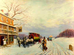
The Conestoga Wagon
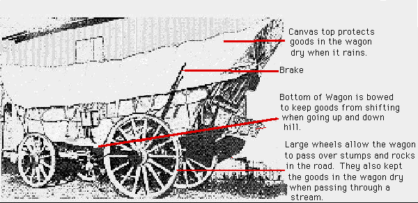
This picture is adapted from the Journal of the
Lancaster County Historical Society, Vol. 51, page 68.
The Conestoga wagon had broad
wheels, the rear wheels being larger than the front, a white fabric hood that
was about 12' long and about 4' 8" high, and a convex, from front to
back, wagon box which was about 8' 10" long and 3' 6" wide. It was
made for a heavy load and with six horses could carry over 7 tons. The Prairie
Schooner used on the plains was much lighter. It used two to four horses and
the wagon box, with the wheels removed, was floated as a boat.
Charlotte-Mecklenburg, North
Carolina
Two
hundred fifty years ago our Scotch-Irish ancestors traveling the great
wagon road from Philadelphia stopped at the crossroads of two ancient
Native American trading paths just east of the Catawba River. There
they built a settlement. As friends and neighbors joined them, the
community grew. In 1768 the town was incorporated and named
Charlotte in honor of the wife of King George III, the reigning English
monarch. Local citizens again honored the Queen when they named the
new county Mecklenburg after her German homeland.
First Scots Presbyterian
Church
 First
Scots Presbyterian Church, the fifth oldest church in Charleston, was
constructed in 1814. Its design was perhaps inspired by St. Mary's
Cathedral in Baltimore, Maryland designed by Benjamin Latrobe. Latrobe was
the first professionally trained American architect, best known for
designing the United States Capitol. The massive brick Presbyterian Church
has walls that are three feet thick and covered with stucco. Twin towers
rise above a columned portico. Reflecting the heritage of the
congregation, the seal of the Church of Scotland is displayed in the
stained glass window over the main entrance, and the decorative wrought
iron grilles contain thistles, the symbol of Scotland. First Scots
replaced the congregation's first church, a frame building previously
located in the southeast corner of the graveyard. The graveyard contains
more than 50 stones that date earlier than 1800. First
Scots Presbyterian Church, the fifth oldest church in Charleston, was
constructed in 1814. Its design was perhaps inspired by St. Mary's
Cathedral in Baltimore, Maryland designed by Benjamin Latrobe. Latrobe was
the first professionally trained American architect, best known for
designing the United States Capitol. The massive brick Presbyterian Church
has walls that are three feet thick and covered with stucco. Twin towers
rise above a columned portico. Reflecting the heritage of the
congregation, the seal of the Church of Scotland is displayed in the
stained glass window over the main entrance, and the decorative wrought
iron grilles contain thistles, the symbol of Scotland. First Scots
replaced the congregation's first church, a frame building previously
located in the southeast corner of the graveyard. The graveyard contains
more than 50 stones that date earlier than 1800.
The congregation of First
Scots dates to 1731 when 12 Scottish families withdrew from the Meeting
House, located at the site where the Circular Congregational Church now
stands. These members formed Scot's Kirk or the Scotch Meeting House, and
were associated with the Presbytery of Charleston and later the
Presbyterian Church of the United States. Their first building was
finished in 1734 and used for worship until the current church was built.
Unique silver and pewter tokens were used for admission to Communion.
During both the Revolutionary War and Civil War services were not held.
Like many other buildings in Charleston, the church was damaged by the
1886 earthquake, as well as a hurricane the year before. Presbyterians
from the North assisted in the restoration of First Scots, and two other
Presbyterian churches in Charleston damaged by these natural disasters.
Several memorial windows remain that were placed after the earthquake.
Recently an English bell made in 1814, the year of the church's
construction, was hung in the north tower, replacing the original which
had been given to the Confederate army for cannons. First Scots
Presbyterian is one of more than 1400 historically significant buildings
within the Charleston Old and Historic District.
First Scots Presbyterian
Church is located at 53 Meeting St. near its intersection with Tradd St.
The church is open to the public. Call 843-722-8882 for further
information. |

