|
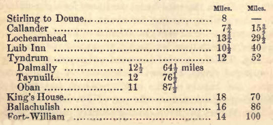
Stirling to Tyndrum ;
Stirling Rock and Castle; Town, ]—Field of Bannockburn, 2. Kincardine Moss;
Valley of the Forth and Teith, 3.—Boone Castle, 4.—Callander; Falls of
Brackland; Plain of Bochastle; Ben Ledi; peculiar observances on Beltein
Day, 5,—Pass of Leni; Loch Luhnaig ; Bob Roy's Grave, 6.—Loch Earn; Glen
Dochart, 7.—Callender to Loch Catrine, tc.—Attractions of the scenes of the
Lady of the Lake, 8.—Lochs Achray and Venac ar, 9.—Loch Catrine; The
Trosachs, 10.—Strathgartney; Passes to Loch Voil and Strathire, 11.—Route to
Loch Lomond, 12.—Loch Chou and Lochs Ard, 13.—Clachan and Pass of Aberfoil ;
Loch Monteith; Ruins of Inchmahome Priory, 14.
1. FOR several miles before
it joins the Firth, the river Forth rolls in many a tortuous maze through a
rich and spacious plain ; its ample flood but slightly depressed below the
level of the fattened soil. At a short distance from the northern bank of
the river, the Ochils bound this teeming flat. Until it reaches this
expanse, the course of the river lies through a wide and level valley. At
the mouth of the valley, an isolated eminence rises on the south side of the
river, with a somewhat steep slope on the south-east, and on the opposite
side presenting an abrupt acclivity, surmounted by a ledge of trap rock. The
stratum dips (to speak technically) to the south-west, and the rocky
precipice gradually increases in height as it ascends from the plain, till
towards the summit it becomes a cliff of considerable elevation, composed of
basaltic columns, from the edge of which rise the walls of Stirling Castle.
The town is built chiefly on the slope of the hill.
Stirling Castle figures in
history as early as the twelfth century, having been one of the strongholds
which formed the pledges of payment of the ransom of William the Lion ; and
indeed mention is made of it as the rendezvous of the Scottish army some
centuries earlier, when the victory over the Danes at Luncarty was achieved.
And Stirling was a military station under the Romans. The castle has
sustained numerous sieges, especially during our struggles with the haughty
Edwards. Here James II. and IV. were born, and James V. and Queen Mary
crowned, and James VI. passed his early years under the tuition of George
Buchanan ; and it was a favourite residence of all the Stuarts, by whom the
greater part of the present buildings were erected. They compose a small
square, one side of which, the parliament hall, was built by James III., the
palace by James V., the chapel (now the armoury) by James VI. The exterior
of the palace, embellished as it is by grotesque busts, fanciful statues and
columns, affords a curious specimen of the bizarre and fantastic taste of
the period. The castle mounts twenty-nine guns ; and the armoury contains
15,000 stand of arms and a few reliques of Scottish story, the most
interesting of which is a pulpit of rude workmanship shown as Knox's pulpit.
On the Gallow Hill, a mound on the eastward of the castle, Duncan, Earl of
Lennox, the Regent Duke of Albany, his son Walter, and his son-in-law and
grandson, were beheaded in May 1425; while Douglas' room, looking into the
governor's garden, was the scene of the Earl's murder by James II. Stirling
rock and castle are very imposing in appearance from many points, but
especially from the vicinity of the field of Bannockburn, on the Glasgow
road ; and the view from the castle is perhaps unequalled in Scotland,
combining with great extent and extreme fertility a magnificent range of
mountains lining the upper portion of the valley, while the spacious and
luxurant plain at the head of the Firth gradually ascends on the south in
receding slopes of the same highly cultivated character. In this direction
the eye roams over a spacious flat of the highest fertility ; ascending, on
the south, in a far reaching inclination of the same character, and to the
east, giving place to the waters of the Firth, with Edinburgh looming in the
distance. Northwards, the moderately elevated sides of the valley conduct to
the splendid mountain screen formed by Ben Ledi, Ben Vorlich, Ben Lomond,
and other alps. The convoluted windings of the river ; the strange
contortions of which may be judged of from the fact, that they lengthen the
distance by water to Alloa to twenty in place of six miles, betoken the dead
level of the surrounding plain. Altogether a richer prospect cannot be
conceived, nor can there be a point of view more favourable, commanding an
unobstructed range in every direction. A hollow below the castle parade,
called "the Valley," was the scene of the joust and tournament, where beauty
oft has dealt the prize to valorous achievement. At the lower end of the
parade is an antique square edifice, with central court and extinguisher
turrets, shooting up from the interior angles. It belonged originally to the
Earls of Stirling, and afterwards to the Argyle family. Not far from it, at
the head of Broad Street, is a ruinous structure called "Marr's Work,"
built, about 1570, with stones from Cumbus Kenneth Abbey. Beside it stands a
handsome Gothic church, built by James IV., the chancel of which was added
by Cardinal Beaton. King James VI. was crowned in the church, and the
coronation sermon was preached by John Knox. All these buildings are near
the brink of the rock, along the face of which a terraced walk is carried
round the castle. On the plain below is a circular mound, the Knott, known
as King Arthur's Round Table, once the centre of courtly pastime.
The town, which consists
chiefly of a narrow and irregular street, descending from Marr's Work in a
slanting direction to the plain, is of an antiquity as remote as the castle,
for it was known as a royal burgh in the reign of Alexander I. It is
distinguished for the number of hospitals it contains for the support of
decayed tradesmen and guild-brethren and their children. The population
amounts to about 7000. The Episcopal Chapel is worthy of notice. Though not
large, it is perhaps the most tasteful structure of the kind in Scotland. A
handsome new Presbyterian Church has been erected near the chapel. Carpeting
and tartans form the chief manufacture. Drummond's Agricultural Museum is
worthy of a visit. About half-a-mile above the old bridge of Stirling, there
was a wooden bridge, memorable as the scene of Wallace's victory, in 1297,
over the English under Warenne and Cressingham. A little to the east of the
bridge is the Abbey Craig, whence the Scottish host descended to the fray,
so called from Cambuskenneth Abbey, of which the ruins stand on the
adjoining plain.
2. Within less than three
miles of Stirling, to the southwest, lies the field of Bannockburn—a spot
peculiarly dear to every Scottish breast. The battlefield and position of
the rival armies is easily understood ; and some venerable handicraftsman is
generally at hand to narrate the traditionary account. The ground rises with
a very gentle inclination on either side of the narrow haugh land, which
skirts a small streamlet. On the northern slope, quite near to the 'village
of Bannockburn, "the Bore Stone," where the Scottish standard spread its
folds, indicates the centre of the Scottish array. The front extended to the
village of St. Ninian's, and rested, on the right, on the Bannock burn. A
little way behind, and to the right, is "the Gillie's Hill," the appearance
on which of the camp sutlers, opportunely conveyed the impression of a
reinforcement to the ranks of their countrymen. As the bottom of the low
ground was a marsh, the encounter between the Bruce and Sir Henry de Boune
is conjectured to have occurred on the elevation towards Milton of St.
Ninian's. The desperate skirmish, at the same time, between a body of horse
under Sir Robert Clifford—which had nigh outflanked the Scottish army, and
effected their object of throwing themselves into Stirling Castle —and of
infantry, under Randolph Earl of ,Moray, took place on the low ground to the
north-east of St. Ninian's, the day before the main battle, Moray coming off
victor. This great conflict, which gave freedom to our country, and inspired
the most spirit-stirring of our national songs, was fought on Monday, 24th
June 1314. The command of the centre of the Scottish host was committed to
the Earl of Moray ; of the right wing to Edward Bruce ; and of the left to
Sir James Douglas and Walter the Steward of Scotland ; Bruce himself, with
Angus of Isla, taking immediate charge of the reserve, immediately behind
the centre, and composed of the men of the Isles, Argyle, Cantyre, Carrick,
and Bute, with a body of 500 well-appointed cavalry. The English van was led
by the Earls of GIoucester and Hereford, and commenced the fight, by
attacking the Scottish right wing. The main body of the English army was
commanded by King Edward in person, attended by the Earl of Pembroke, Sir
Ingram Umfraville, and Sir Giles de Argentine. The tourist should not omit,
on quitting Bannockburn, to hie him to the south end of the adjoining
village of Milton of St. Ninian's, where, near the mill, and close by a
cottage on the site of that into which he was carried—and of which one of
the identical gables still subsists—is the well where James III. was thrown
from his horse on his flight from the battle of Sauchieburn. The king's
horse, it will be recollected, was startled by a woman who was drawing water
suddenly raising herself, and the monarch was thrown, and being carried into
the mill, was stabbed by a person who came up, supposed to be Stirling of
Kier.
The celebrated Roman camp at
Ardoch, near Dunblane; the ruins of the Cathedral; Archbishop Leighton's
Library, and some other objects about DunbIane; and the field of the battle
of Sheriffmuir, invite description. But we have already lingered beyond the
Highland boundary as long as our limits permit, and must hasten to reconduct
the reader towards the hilly North.
One continuous but serpentine
thread of successive valleys penetrates the mountain maze, from Stirling to
the western confines of Inverness-shire. This natural line of communication
was selected as one of the great military roads of the early part of the
last century; and now it forms the drove road for the cattle of the west
coast and islands, and a delightful route for the tourist,though still not
the best in the world for four-in-hand.
3. Proceeding up the wide
valley of the Forth, the road passes the house of Craigforth, opposite which
is seen the house of Kier, (Stirling,) and, two miles from Stirling, crosses
the river at the Bridge of Drip. It then runs for several miles through what
is still called the Moss of Kincardine, though now rich cornfields occupy
the greater part of this once marshy and bleak tract. About eighty years
ago, the late Lord Kaimes became proprietor of 1500 acres of the moss,
which, to his shrewd intellect, appeared readily reclaimable from its then
unprofitable condition. At an average depth of seven feet below the surface
of the moss, a substratum of rich carse clay, with a thin covering of
vegetable mould, held forth the prospect of a most inviting return for the
expense of disencumbering it; and as his Lordship's possessions extended
from the Forth to the Teith, which flows along the north side of the valley,
a large wheel was erected to lift water from the latter stream for the
purpose of floating the moss, by means of drains cut in the clay, into the
Forth. Portions of the moss were let to tenants, in lots of eight acres, on
leases of three nineteen years; without rent the first nineteen ; twelve
shillings for each acre brought into culture the second nineteen years; and
so increasing, till, towards the close of the lease, they come to pay a
guinea per acre. About 200 families are now settled on this portion of the.
moss, who live in neat houses disposed in regular lanes, and equidistant
from each other. On the expiry of the whole leases, a rental of between
£4000 and £5000 a-year will be the fruit of this judicious improvement.
For about four miles above
Stirling, the valley continues of considerable breadth. It then becomes
still wider. The lower part, a dead level of the richest curse land, is
lined on the north by a low and sloping rising ground, cultivated and wooded
; the verdant hills opposite are of moderate size, but a noble mountain
screen rises behind the northern side, and stretches across the upper
extremity of the valley. Ben Ledi, Ben More, and Ben Lomond, are the most
prominent of these alps.
Five miles and a half from
Stirling, the road passes the House of Blair-Drummond, the residence of Mr.
Home Drummond, I.P., embosomed in fine woods and plantations ; and half a
mile farther on, at the church of Kincardine—a neat specimen of the modern
Gothic—the Callander road, ascending the low sloping side of the valley of
the Forth, ushers us into a new district of country, watered by the Teith.
The valley of the Teith, betwixt the Forth and Callander, is almost filled
up with a spreading terrace descending from the summit of the smoothly
outlined hills, in most gentle undulations, which are highly cultivated, and
variegated with clumps, belts, and rows of hardwood, pine, and larch trees,
presenting an extended surface, apparently not less than a couple of miles
in width, of fertile fields and nodding woods, peculiarly beautiful. The
Teith glides smoothly on between low and richly wooded banks.
4. On the further side of the
river, eight miles from Stirling, stand the village and Castle of Doune. The
castle, a massive and very imposing structure, said to have been built about
the commencement of the fifteenth century, by Murdoch, Duke of Albany,
overhangs the point of a steep and narrow green hank, washed on one side by
the Teith, and on the other by a small mountain burn, and is conspicuously
situated where a very gentle hollow on the east, communicating with Dunblane,
still further enlarges the far-extended surface of corn-fields and woods
presented to the eye. At one end of the front a spacious square tower rises
to the height of about eighty feet: another, not quite so large, shoots up
from behind the opposite extremity. A strong back wall, about forty feet
high, forms the whole into an ample quadrangle. The princilie room in the
building, between the towers, is seventy feet long; that in the great tower
forty-five feet by thirty: the kitchen fire-place seems capacious enough to
have admitted the whole household to ensconce themselves beneath the
chimney. The exterior angle of the main tower, bulging out into a rounded
projection of goodly proportions, considerably heightens the appearance of
solidity and strength. A ponderous grated gate still exists within a heavy
iron-studded folding-door ; and, though roofless, the walls are entire.
Stately elm, plane, and ash trees surround this venerable stronghold. The
tourist will view this interesting structure with additional regard, since
it has been depicted in the classic pages of "Waverley," as the place of
durance whither his Highland captors carried that English chevalier. The
village of Doune, a little removed from the edge of the river, contains a
considerable number of slated houses. It was of old celebrated for the
manufacture of Highland pistols. A part of the inhabitants now derive their
subsistence from cotton works, established where the road crosses the river.
In the immediate vicinity is CambuswaIIace, a seat of the Earl of Moray,
and, at the distance of three miles from Doune, Lanrick Castle (Jardine), on
the opposite margin of the river.
5. As we advance towards
Callander, the sloping uplands assume more of a pastoral character. Near it,
pass Cambusmore (Buchanan), where Sir Walter Scott passed the greater part
of his boyhood, and Gart House (Stewart). This village is situated at the
foot of the chain of mountains which, stretching to the westward, form the
Highland boundary ; and on the north side of a flat plain, through which the
Teith, meandering, assumes a change in the direction of its course, which,
from its original easterly one, here deflects to the south, towards the
Forth. Callander consists chiefly of a long row—on each side of the road—of
neat white-washed and slated houses ; the greater number of one storey. It
contains a suitable church and school-house, and excellent inn. An older
portion of the village occupies the south side of the river, which is
crossed by a substantial bridge. Behind Callander, to the north, the face of
the bounding hills presents an ample, lofty, and perpendicular rocky front,
with scattered trees. Beneath it is spread the spacious and highly
cultivated plain of Bochastle. Several of the inhabitants employ themselves
in weaving their neighbours' yarn and wool into towelling, table-cloths,
tartan, and other coarse fabrics, for home consumption and for sale. The
Falls of BrackIand, about two miles to the cast of the village, may serve to
occupy a leisure hour. They consist of a series of short falls, shelving
rapids, and dark linns, formed by the Keltie Burn, in its progress through a
low rocky chasm, descending a succession of horizontal ledges of rock. A few
trees thrown across used to afford scope for some little trial of resolution
in adventuring the defenceless passage: now, a frail railing dispels all
sense of danger. Rich corn-fields and woods, with several elegant villas,
cover the flat surface of Bochastle, the plain through which, at Callander,
the sinuous river holds its course. Some curious winding banks near the
stream encompass considerable spaces of ground, which are laid out in
terraced walks and tasteful shrubberies. On the Dun of Bochastle are the
traces of a fortification, having the remains of three mounds and ditches. A
straight artificial bank, on either side of the eminence, is conjectured to
have been designed for the practice of archery. To the westward the Teith is
joined, from the north, by the river Lubnaig. The lofty mountain rising
between is Ben Ledi, "The Hill of God," upwards of 3000 feet in height. In
early ages, tradition reports that it was customary for the people to
assemble, for three successive days, on its summit, for the worship of their
deity; most probably, of Baal, or the sun. A small lake on Ben Ledi is
called Lochanan-Corp; a name commemorative of the incident of a whole
funeral party from Glenfinlas, who were crossing it when frozen over, having
been drowned by the ice giving way.
Within a recent period some
practices were observed in the parish of Callander—not, however, confined to
it—which seem to be vestiges of Druidical rites. On Bel or Baal-tein, the
first day of May, it was customary for the boys to meet, and cut a circular
trench in some verdant spot, in the centre of which a fire was lighted. A
sort of custard of eggs and milk was dressed, and an oatmeal cake was
prepared. When the former had been discussed, the cake was divided into
pieces corresponding with the number present, and, one bit being blackened,
the whole were put into a cap, and each individual drew one. He who had the
misfortune to fall upon the black piece was the victim to be sacrificed to
Baal, to propitiate his genial influence for a productive season. On All
Saints' eve, numerous bonfires were lighted, and the ashes of each collected
in a circular heap, in which a stone was put near the edge for every person
of the hamlet, and the individual whose stone happened to be displaced by
the following morning was regarded as fey; i.e. one whose days were
numbered, and not to be expected to survive twelve months.
6. Continuing our course
northward, about a mile beyond Callander, the road passes through a village,
consisting of a few scattered, thatched, and tiled huts, called Kilmahog;
and, shortly after, enters the Pass of Leni. The river—a tributary of the
Teith, as already observed—is lined with eminences, at first low and bare,
but gradually increasing in height, and soon becoming covered with a dense
oak coppice; and the stream is found making a large, circular sweep along
the foot of Ben Ledi's crescent sides, which, above a heathy slope, uprear
two successive lofty and perpendicular rocky precipices, each surmounted by
a high pale-green acclivity. This pass leads to the extremity of Loch
Luhnaig, " The Crooked Lake ;" a narrow sheet of water, about five miles in
length, of which the central part forms nearly a right angle with either
extremity. The hills on both sides are steep and lofty, and press closely on
the water. Those on the west and south are particularly bold, almost wholly
bare rock, and all but perpendicular, and their broad shadows give an air of
peculiar gloom to this lake. A portion of the eastern side, at the northern
extremity, is wooded with oak, birch, ash, and beech ; the rest of the
mountains are bleak and hare, with the exception of stunted alders, fringing
the water-courses on the lower slopes, and some scattered trees around
Ardhullary. This is a farm-house, about the middle of the east side ;
classical as the retreat in which the celebrated traveller, Bruce, secluded
himself when composing his work on Abyssinia. About a mile from the north
end of Loch Lubnaig is a small village, called Immirrioch, and to the
country people known by the byname of Nineveh, consisting of about thirty
houses; most of them one-storeyed and slated.
The district of country lying
between the end of Loch Lubnaig and Lochearnhead is called Strathire, and is
joined, about half-way, by another valley from the west, called Balquhidder.
Balquhidder is chiefly occupied by the waters of Loch Voil and Loch Duine.
It was at the upper end of Loch Yoil that the noted Rob Roy, for the most
part, lived in the latter days of his life ; and he is buried in the Kirkton
of Balquhidder, at the lower end of the lake, and about two miles distant
from the public road. The arms on his tombstone—a fir tree, crossed by a
sword, supporting a crown—denote the relationship claimed by the Gregarach
with the royal line of Stuart. Our readers will recollect the circumstance,
in the novel of "Rob Roy," of Rob's escape in crossing the river. Such an
incident as is there narrated did occur in the braes of Balquhidder. A
party, headed by the Duke of Montrose, having succeeded in laying hold of
him, he was buckled behind Grahame of Gartnafuorach, who, unable to
withstand the captive's remonstrances, slipped the belt when they had
reached a spot where the fragments of rocks strewing the hill face precluded
the possibility of pursuit with horses.
7. Lochearnhead, where there
is a comfortable inn, is three miles from the opening of Balquhidder. The
lake is about seven miles in length, and a mile across where broadest, and
is environed by moderate sized hills, of a soft and flattish outline, which
possess much sweetness of character, notwithstanding that their height is
considerable.
Glenogle, next in succession
on the course of the northern road, is for the first few miles very narrow,
and the mountains strikingly grand ; rising, on one hand, in a steep
acclivity, surmounted by perpendicular precipices ; on the other, in a
succession of terraces in short perpendicular falls and abrupt slopes. The
rest of the way to the valley of the Dochart is a dreary waste.
The bottom of Glen Dochart is
chiefly flat meadow-ground as far as Luib Inn (ten and a-half miles from
Lochearnhead), when it is found occupied by irregular eminences, springing
up from either side. These are succeeded by two small lakes, Loch-an-Our and
Loch Dochart ; beyond which Strathfillan presents a narrow tract of
meadow-ground. The hills rise in various inclinations, but are continuous,
and they shoot up into distinct summits. Ben More, whose conical summit is
preeminent on the south side, rises in one continued acclivity from the side
of Loch-an-Our. The glen is open, with a few trees at wide intervals
scattered over its surface. The junction of the road from the head of Loch
Lomond with the main line, is at Crinlarich, a public-house between three
and four miles from Tyndrum.
Occasionally conveyances run
from Stirling to Tyndrum, in connection with the Oban and Fort-William
coaches.
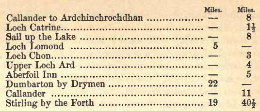
CALLANDER TO LOCH CATRINE.
8. The scenery of the chain
of lakes immediately to the west of Callander, through which the main branch
of the Teith successively holds its course, has acquired a degree of
celebrity almost unparalleled, the genius of a Scott having invested it with
all the charms of perhaps the most generally engaging and popular, as they
are among the earliest and freshest, of his creations. And the treasures of
his fancy could not be more fittingly enshrined, for the hand of Nature has
here, too, lavished, some of its most exquisitely beautiful realities. Such
combined influences have conspired to render the Trosachs and Loch Catrine
of peculiarly favourite resort. And they do well sustain their high
reputation. The picturesque solicits our admiration with heightened
interest, associated as each spot is with romantic and poetic story.
Foremost perhaps is the impulse to cast anxious and inquiring glance around,
to determine a local habitation for each varying image and incident of the
poem cherished in fond remembrance. The sight of Loch Latrine may suggest
the stately galleys of Roderick Dhu-
"Steering full upon the lonely
isle;"
the mountain echoes answering
the loud strains of Clan Alpine's pibroch, or the rocks resounding to the
praises of its chief, chanted by the voices of a hundred clansmen: fair
Ellen and her skiff—the Douglas, "Stalwart remnant of the bleeding heart"—Fitz
James and his gallant grey, flit across the mental vision.
In undertaking the duties of
a guide, it shall be our endeavour at once to delineate the character of
this much-famed district, and to direct the traveller to the position of the
more prominent localities of "The Lady of the Lake."
9. The mountain range, which
forms the outskirts of the Highlands, runs for several miles due west from
Callander, and then deflects to the south, towards Ben Lomond. Lochs Achray
and Venachar, into which the waters of Loch Catrine discharge themselves,
lie on the outside of the highland boundary; while the latter is encompassed
by mountains, through which a communication has been formed between Lochs
Catrine and Achray by some great convulsion of nature, sweeping away the
connecting link between Ben A'an and Ben Venue. These mountains, that,
like giant stand,
To sentinel enchanted land,"
present on each side lofty
and inaccessible precipices: and the intermediate pass, known as the
Trosachs, or, "bristled territory," in Gaelic etymology, is occupied by
intricate groups of rocky and wooded eminences : on the south sides of Lochs
Venachar and Achray rise sloping heathery hills, the bases of which are
fringed with wood and oak coppice. Ben Ledi, the hill of God, towers on the
north. The range which connects it with Ben A'an swells out unequally; at
times sending down ragged heights clad with dense foliage, which overhang
the edge of the water in steep acclivities, and enclose between them plots
of open uneven ground. Loch Venachar is four miles long, and three quarters
of a mile across at the broadest part; Loch Achray a mile and a-half long,
and its greatest width one mile. Both of them narrow towards the east end.
From Callander to Coilantogleford, at the lower point of Loch Venachar,
where Roderick Dhu was overcome by Fitz James, is about two and a-half miles
; the space between that lake and Loch Achray, by the road, about two miles,
and from the western extremity of the latter to Loch Catrine, one mile or
more ; making the whole distance from nine to ten miles. Lanrick Mead, the
mustering-place of clan Alpin, lies on the north side of Loch Venachar,
where the road diverges from the lake: a little way on, on the face of the
hill towards the left, is the farm of Duncraggan. The Brig of Turk crosses
the water, which, descending from Glenfinlas, joins the Teith between Lochs
Venachar and Achray; and advancing a mile and a-half beyond it, we reach the
commodious new inn of Ardchinchrochdhan, beautifully situated on the side of
Loch Achray, and itself an imposing semi-castellated structure, differing
widely from its equally attractive predecessor, which, with its rustic work
and creepers, transported the fancy to southern climes.
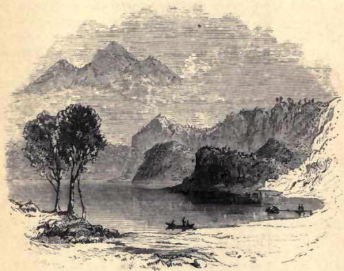
10. Loch Catrine is of a
serpentine form, encircled by lofty mountains, and is ten miles in length,
attaining in some places a breadth of two miles. From the varying surface of
its girdling frame of hills, and its own inflections, it presents
considerable diversity of aspect from different points of view. The narrow
river which conducts its waters to Loch Achray keeps the southern side of
the intermediate isthmus, sweeping by the foot of the precipices of Ben
Venue. Between the river and Ben A'an, occur, as already observed, various
short rocky ridges, rising into summits of different characters; some more
or less spiry; others presenting elongated outlines. This labyrinth is
tangled o'er with a forest of oak coppice, birch, and brushwood; which
likewise climb high up the face of the long and almost vertical side of Ben
A'an. Ben Venue not many years ago could also boast a myriad of noble trees,
which the extreme irregularity of its shattered rocky sides threw into the
most varied and effective groups. The lover of the picturesque has to lament
the removal of those graceful appendages; still its noble form, its grey
perpendicular cliffs and green acclivities, rising tier upon tier, high in
air, and partially screened by a huge portion of itself, detached from the
parent hill by a deep defile, and presenting to the lake a mass of shivered
fragments of rock, the memorials of some great convulsion, in connection
with this rugged foreground, 'which again is flanked by sheeted masses of
brilliant emerald, possess altogether a singularly arresting majesty and
grace; while at the base lie the terminal eminences of the Trosachs,
shrouded in foliage, and deeply intersecting the confined and sheltered
waters of the lake. But we must draw from a higher source to do justice to
such a scene:
The rocks of the Trosachs, as
already stated, extend in successive promontories into the lake, and
occasion so many narrow inlets. A terminal portion of one of these
headlands, detached from the adjacent shore, and covered with wood, will be
recognised as " the Isle" of the poem. In the defile of Bealana-Duine, where
Fitz-James' steed fell exhausted, we are in the heart of the great gorge.
Then appears a narrow inlet, and
a moment after Loch CATRINE
itself, in the full blaze of "living light," bursts upon our view, its sides
descending in circling wooded slopes; the Alps of Arroquhar towering in the
distance.
The variety of scene is great
and striking, alike from spaciousness of expanse and intricacy of detail:
impending wooded rocks, shaded bowers, secluded inlets, an ample lake, and
extensive mountain ranges. The form of Ben Venue is certainly remarkably
noble: faced with abrupt but verdant acclivities and grey rocky spaces, and
sending down long ramifications to the lake, it enters into most of the fine
landscapes to which the wooded eminences of the Trosachs, and shores of Loch
Catrine form such splendid foregrounds. Ben A'an is not so prominent, but
its lower acclivities shrouded with wood are exceedingly rich, while above
them it uprears a naked pyramidal summit, which forms a remarkable object
from various points.
Coir-nan-Uriskin, 11 the Den
of the Ghost," will attract a share of the traveller's notice. It is marked
by a deep vertical gash in the face of one of the extensive ramifications of
Ben Venue, overhanging the lake: an abrupt rocky mass rising from the edge
of the water, above alluded to, is flanked on either side by a ravine, which
stretches up the hill, the intervening acclivity being strewn with immense
fragments of stone. Here Douglas concealed his daughter, when he removed her
from Roderick Dbu's island. Above the top of the eastern hollow is
Bealachnambo; the pass by which, in days of black-mail and reivers, cattle
were driven across the shoulder of the hill.
The island was always the
resort of the women and children on occasion of hostile incursions. One of a
party of Cromwell's soldiers is related to have swam out for the purpose of
unmooring a boat, that his comrades might revenge on the defenceless
occupants of the isle the death of one of their number who had been shot in
the Trosachs. As he neared the island, his fellow soldiers looking on, one
of the women severed his head from his body, a spectacle which induced the
hostile party to make the best of their way out of the intricate defiles
they had ventured into.
We would recommend the
tourist not to content himself with what is to be seen of the Trosachs from
the road, but to explore their untrodden mazes, and especially to follow the
old track, which will be observed on the right, on quitting Loch Achray, and
which will conduct him to the foot of the wooded precipices of Ben A'an.
After being ferried over to Coir-nan-Uriskin, he should return by the south
side of the river.
There is now a small steamer
on Loch Catrine, and a keen competition in coaching is kept up to and from
Stirling and the Bridge of Allan.
11. It may be well to remark,
for the benefit of pedestrians who mean to extend their rambles farther
north, that if, instead of retracing their steps to the Pass of Leni, they
follow on the east bank the course of the stream which is crossed by the
Brig of Turk, they will very soon find themselves among the secluded
hamlets-of Strathgartney. From hence they may proceed to Lochearnhead, by
either of three glens which will be found to descend into the strath.
Glenfinlas, the most westerly, conducts to the side of Loch Yoil ; Glen
Main, the central one, to the Kirkton of Balquhidder, at the lower end of
that lake ; and Glen Cashaig, by the west end of Loch Lubnaig, into
Strathire. This last is the shortest, but it will take about six hours'
walking to reach Lochearnhead from Ardchinchrochdhan. The pass between Glen
Cashaig and Strathire rises to a considerable elevation, and an alpine view
is obtained from the top, of surpassing magnificence, comprehending some of
the loftiest mountains in Scotland—Ben Voirlich, Ben More, and Ben Lawers,
with their contiguous ranges. The descent into Strathire is very steep, and
it is necessary at the commencement to keep well to the left hand, along the
face of the hill.
12. If the traveller's route
be towards Loch Lomond, a sail of eight miles will bring him near the west
end of Loch Catrine. The little steamer plies in connexion with the Loch
Lomond boat. There is a clean bothy at the west end of Loch Catrine, where
refreshments can be had, and on reaching Loch Lomond a smart new inn will be
found at the water side. It is rather odd, in the near vicinity of Glasgow
and Edinburgh, and in a locality teeming with tourists, to find roads of so
very inferior a description as connect Loch Catrine, Loch Lomond, and the
contiguous Lochs Ard, Chon, and Monteith; and indeed parts of the road to
the Trosachs, are very unsuitable to the locomotion to which it is
now-a-days subservient. The district road trustees might beneficially bestir
themselves, and make some little exertion to keep pace with the advance of
the age. The intermediate distance of five miles thence to Inversnaid (where
the Loch Lomond steam-boat touches), through an upland valley bounded by
bare hills, must be traversed on foot or with the aid of a country pony.
Ponies and cars are accordingly kept for that purpose at the boat-house. In
one of the smoky huts on the way may be seen a long duck-gun, once the
property of the renowned local hero Rob Roy. Towards the east end is a small
tarn called Arclet, and within a mile of Loch Lomond, on an esplanade at the
foot of the hills on the north side, stand the ruins of Inversnaid fort, a
military post indicatire of the once turbulent habits of the MacGregors, and
other natives.
Lochs Chon, Ard, and .Monteith
13. We shall suppose our
tourist desirous of paying a visit to the beautiful but less known scenery
of Loch Chon, Loch Ard, and Loch Monteith, on the course of the Forth. A
branch of the rugged path to Inversnaid fort strikes off about a mile from
Loch Catrine, and at the eastern extremity of Loch Arclet. At a distance of
rather less than three miles we reach Loch Chon, and its little islet, a
secluded sheet of water about one and a half mile in length, and half a mile
in breadth; and of a character which impresses a sense of subdued repose
upon the mind. It is bounded on the south by a lofty and green mountain,
rising in a steep acclivity, and its opposite shore is fringed with coppice.
Two miles further on, the intermediate space being occupied with corn-fields
fringed with hazel and coppice, Upper Loch Ard comes into view; and a
romantic waterfall is not far off. It is about two miles long, and perhaps
one broad, surrounded by low rocky and wooded hills, their low shores
patched with arable ground, and about midway is a comfortless-looking inn.
The road courses along the margin of the lake under a ledge of perpendicular
rock, at the west end of which is an echo of considerable power. Secluded,
sweet, and peaceful in character, this lake is still deficient in interest
till the lower end is reached. There the view westward is splendid. The
lake, somewhat narrowed, is here lined by wooded ledges of rock, with short
wooded promontories, and the whole sheet of water immediately surrounded by
a series of wooded eminences, surmounted by higher heights behind; on a
rocky islet, moulder the ruins of a stronghold of Murdoch, Duke of Albany.
At the further end of the lake rises Ben Lomond in great majesty, its
graceful peak towering high in air, and between it and the loch, in like
manner, lies an inner and lower frame, giving at once breadth and height to
the imposing mountain screen. The features of Highland landscape begin to be
sensibly softened down, and this change of character is heightened as we
progress onwards. Fertile fields and verdant meadows, crowned by sombre
woods, form prominent features in the landscape intermediate between the
Upper and Lower Loch, the space traversed by the road being about a mile,
though the connecting stream is only about a couple of hundred yards in
length. A footpath strikes off towards Ben Lomond, by which the tourist
could cross the hill, and reach Rowerdennan, on the banks of Loch Lomond; or
he has the choice of the road from Aberfoil Inn, by Gartmore and Dry-men, to
Dumbarton, a distance of twenty-two miles. Lower Loch Ard, which is about a
mile long, and correspondingly narrower than the upper one, has its southern
bank formed by a range of low and bare but steep hills, that on the north by
a wooded ledge of rock closely hemming in the water and the road. From the
lower extremity is presented a most perfect picture. The small lake, with
its steep banks lined with reeds and water-lilies, is displayed in front,
divided by a projection of meadow ground, into two compartments. Beyond rise
the wooded eminences separating Lower and Upper Loch Ard, forming an ample
and rich middle distance, while behind all rises Ben Lomond pre-eminent, the
distinguishing feature of the scene.
At the lower end of the loch
are some pyroligneous works, for which the abundant coppices about furnish
supplies.
14. At the Clachan of
Aberfoil is the junction of the Douchray and Forth, here called Avondhu, or
the black river. Impending and wooded mountains throw a shade over the vale,
which is about a mile in width. Under the rocky precipice on the north, and
the rocky ledges lining Loch Ard, lies the Pass of Aberfoil, noted in times
gone by as the scene of the defeat of a party of Cromwell's troops by Graham
of Douchray and his Highlanders, and still more so, in our day, by the
writings of the author of "Rob Roy."
The tourist will find a
comfortable inn at the Kirkton, a mile or more below the Clachan and Loch
Ard, without any apprehension of meeting a similar repulse to Bailie Nicol
Jarvie's. The path across the hill to the Trosachs is five miles and a-half
long. But to reach Callander, the ordinary plan is to enter the "Port of
Monteith." Below Aberfoil the valley widens very much, attaining a breadth
of even eight or ten miles. The river is skirted by a broad tract of level
land, succeeded on each side by a wide undulating terrace pretty generally
brought into cultivation. Interrupted independent hills border the vale on
the north, while on the south the long, almost horizontal line of the
Fintray hills, surmounted by the lumpish Campsie hills, proclaim that the
,Highlands are now fairly left behind. Three miles below Aberfoil, on the
right, lies extended, in all its smiling compass, the Lake of Monteith, of a
circular form, six miles in circumference, and adorned with aged trees. On
the largest of its two islands are the ruins of the priory of Inchmahome,
founded by Edgar, King of Scotland, where the unfortunate Queen Mary passed
her infancy. The smaller one contains the remains of the castle of the
Grahams, earls of Monteith. The lake is encompassed on the north and west by
level, cultivated, and meadow ground, dotted with aged oak and other trees,
and rising into almost imperceptible slopes. On the south the rising slopes
are clad with fir, and a long point of low land, bearing a row of pines, and
projecting from the shore, with the wooded island of Iuchmahome, almost
intersects the lake. Gartmore House (Graham) and Rednock House, the seat of
General Graham Stirling, eastward of the lake, will attract attention; and
about seven miles after turning our hacks on its waters, at the Port of
Monteith, which is four miles from the inn of Aberfoil, we once more enter
Callander; or proceeding by the valley of the Forth to Stirling, the
distance is fifteen miles. |


