|
The Clyde rises from the northern border of the great
Silurian rocks of the Southern Highlands, flowing along these until
about Symington, where it enters the Old Red and afterwards the
Carboniferous basin onwards to Glasgow. The Silurian system of the
south of Scotland is described as follows by Professor Young: “The
broad undulating district lying to the south of the Carboniferous
basin of Central Scotland, and known under the general name of
the Southern Uplands, is carved almost wholly out of rocks of
Silurian age. The dominant formation is an immense series of
comparatively barren graywackes and shales, which, thrown into
innumerable folds and contortions, spread in an unbroken
sheet from St. Abb’s Head to the Mull of Galloway,
forming by far the grandest exhibition of Middle Silurian Strata yet
discovered.” Page, in his Text Booh of Geology, says: “This system
is largely developed in various countries, both in the Old and in
the New World, and typically so in the district between England and
Wales, anciently inhabited by the Silures; hence the designation
‘Silurian System’ by Sir It. Murchison, their first and most ardent
investigator.”
The Clyde valley presents varied geological features,
and offers a very good field for the study of this now important
economical science. The rocks throughout are of the earlier and
Carboniferous periods, seamed by dykes and capped by overflows of
trappean rocks, indicating great changes of level and conditions in
the past; whilst to the student of the glacial period abundant
evidences of the presence of a great ice-sheet once more or less
filling up the valleys, as the glaciers of Switzerland and Norway
now do, may be met with in the boulders scattered about the lower
levels, the great masses of boulder-clay, and the smoothed and
striated rock surfaces which may still be met with. In reference to
this it may be noted here that “A table-case in the Hunterian Museum
contains a series of hand specimens, obtained by Mr. Young from the
boulders which were removed when the summit of Gilmorehill was
lowered for the foundation of the University. The series includes
all varieties of rock from Bonawe to the Kilpatricks. The glacial
striations of the district are generally from north-west to
south-east.”
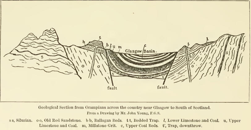
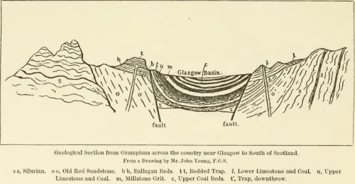
If we take a sectional view of the country, in a line
running north and south through the Clyde valley and passing through
the Glasgow district, we find the Silurian rocks appearing to north
and south, as a framework on which rests deposits of Old Red
Sandstone, on which, in turn, rest the limestone, shales, and coal
and iron beds of the Carboniferous period. Ejections of trappean
rocks are frequently met with in the later deposits, troubling the
miner by causing upthrows and downthrows.
The most widely-spread and most interesting series,
in an industrial point of view, is the Carboniferous, covering-all
the middle portion of the Clyde valley, and extending to a depth of
several thousand feet. The series consists mainly of beds of coal,
iron-stone, shales, and fire-clay, with their accompanying
limestones and sandstones.
The great “fault” already referred to as crossed by
the Rotten Calder has caused the downthrow of the great coal-beds to
a level with the lower deposits of the carboniferous limestone,
shown in a geological map of the district by a sharp dividing line
between the dark-coloured portion (the coal) and the bluish (the
limestone). The amount of this displacement equals that of the
thickness of the beds awanting, and has been estimated at about 1500
feet. Speaking of the limestones to the south of Glasgow Mr. Bell
(Rocks around Glasgow) says:—
“They are also often called the ‘cement limestones,’
being largely used for cement and building purposes, as from a
certain admixture of silica and alumina in their composition they
have the property of ‘setting’ with a firm band under water. The
Orchard limestone is wrought at a short distance to the south of
Giffnock Quarries. It is also wrought as the ‘Lyoncross’ limestone
at Nitshill and Barrhead, and is known as the ‘Williamwood’
limestone near Cathcart. It is only a thin bed, from 18 to 26 inches
in thickness, but is of excellent quality, and has long been
esteemed as a cement limestone. Underneath it is a thin seam of
coal, which is used in calcining the stone. The Arden limestone,
wrought extensively near Thornliebank and Barrhead, is in much
greater mass, attaining a thickness of 8 to 10 feet, in some places
even more. Its equivalent to the north of the Clyde, in the Garnkirk
district, is largely used for iron-smelting.”
The varieties of coal, and varying condition and
thickness of the limestone and sandstone beds, all point to long
periods of land surface, with correspondingly extended periods of
depression under the surface of the water.
Professor Geikie, in his Scenery of Scotland, thus
graphically describes the Clyde valley:—
“While the three main rivers resemble each other in
thus breaking through a chain of hills to find their way into their
firths, they present many points of difference in their respective
courses across the lowland valley. Perhaps the most interesting is
the Glyde. Drawing its waters from the very centre of the southern
uplands, it flows transverse to the strike of the Silurian strata,
until entering upon the rocks of the lowlands at Roberton it turns
to the north-east, along a broad valley that skirts the base of
Tinto. If the reader will glance at the map he will notice that at
that part of its course the Clyde ap-proaclies within seven miles of
the Tweed. Between the two streams, of course, lies the watershed of
the country, the drainage flowing om the one side into the Atlantic,
and on the other into the North Sea. Yet, instead of a ridge or hill
the space between the rivers is the broad flat valley of Biggar, so
little above the level of the Clyde that it would not cost much to
send that river across into the Tweed. Indeed, some trouble is
necessary to keep the former stream from eating through the loose
sandy deposits that line the valley, and finding its way over into
Tweeddale. That it once took that course, thus entering the sea at
Berwick instead of at Dumbarton, is probable; and if some of the
gravel mounds at Thankerton could be re-united it would do so again.
Allusion has already been made to this singular part of the
water-shed. Its origin is probably traceable to the recession of two
valleys, and to the subsequent widening of the breach by atmospheric
waste and the sea.
“From the western margin of the Biggar flat the Clyde
turns to the north-west, flowing across a series of igneous rocks
belonging to the Old Red Sandstone series. Its valley is there wide,
and the ground rises gently on either side into low undulating
hills. But after bending back upon itself, and receiving the Douglas
Water, its banks begin to rise more steeply, until the river leaps
over the linn at Bonnington into the long, narrow, and deep gorge in
which the well-known falls are contained. That this defile has not
been rent open by the concussion of an earthquake, but is really the
work of sub-aerial denudation, may be ascertained by tracing the
unbroken beds of lower Old Red Sandstone from side to side. Indeed,
one could not choose a better place in which to study the process of
waste, for he can examine the effects of rains, springs, and frosts
in loosening the sandstone by means of the hundreds of joints that
traverse the face of the long cliffs, and he can likewise follow in
all their detail the results of the constant wear and tear of the
brown river that keeps ever tumbling and foaming down the ravine.” |